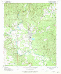
1970 Map of Murfreesboro
USGS Topo · Published 1972About this map
Murfreesboro serves as the focal point of this 1970 survey, situated at the junction of Prairie Creek and the Little Missouri River. The landscape reveals a unique intersection of geological interest and ancient history, notably at the Crater of Diamonds (Diamond Mine) southeast of the town center and the Indian Mounds located near a bend in the river. Rural life is well-documented through a network of country churches and burial grounds such as Maple Springs Ch, Sweet Home Ch, and Valley Grove Cem. Transportation patterns show a transition in the era, with an Old Railroad Grade running through the river bottoms while modern infrastructure like a Substation and Radio Tower reflect contemporary development. The southern portion of the map transitions into the settlements of Kimberley and Sweet Home near the border of Pike and Hempstead counties.
Find a feature on this map
51 named features on this map. Tap any name to fly to it.
Don’t see what you’re looking for? This feature index may not catch every label — zoom into the map to look around manually.
Map Details
Editions of this 1970 Murfreesboro Map
2 editions found
Other maps of this area

1906 · Caddo Gap
USGS Topo · 1:125,000

1951 · Nashville
USGS Topo · 1:24,000

1951 · Pisgah
USGS Topo · 1:24,000

1951 · McCaskill
USGS Topo · 1:24,000

1953 · El Dorado
USGS Topo · 1:250,000

1955 · Little Rock
USGS Topo · 1:250,000

1956 · Little Rock
USGS Topo · 1:250,000

1957 · El Dorado
USGS Topo · 1:250,000

1958 · El Dorado
USGS Topo · 1:250,000

1960 · El Dorado
USGS Topo · 1:250,000