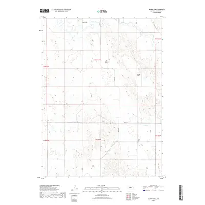
2017 Map of Murphy Table
USGS Topo · Published 2017About this map
Murphy Table dominates this central Nebraska landscape, where the high flatlands meet the branching drainages of the South Loup River. The area’s early 21st-century settlement pattern is defined by isolated communities like Finchville in the north and Sand Valley to the southeast. These small hubs are connected by a network of county roads such as Rye Valley Rd and Sand Valley Rd, which follow the natural contours of the undulating terrain. Genealogists will find the Sand Valley Cem near the southern edge of the survey, a quiet landmark in this ranching country. The map also identifies Stop Table, illustrating the unique "table" topography characteristic of Custer County, where elevated plateaus are deeply incised by seasonal watercourses like Sand Cr. This landscape reflects a long history of dryland farming and grazing adapted to the region's distinct landforms.
Find a feature on this map
26 named features on this map. Tap any name to fly to it.
Don’t see what you’re looking for? This feature index may not catch every label — zoom into the map to look around manually.
Map Details
Editions of this 2017 Murphy Table Map
This is the sole edition of this map. No revisions or reprints were ever made.
Other maps of this area

1951 · Callaway NW
USGS Topo · 1:24,000

1951 · Callaway
USGS Topo · 1:24,000

1951 · Oconto NW
USGS Topo · 1:24,000

1954 · North Platte
USGS Topo · 1:250,000

1955 · Broken Bow
USGS Topo · 1:250,000

1956 · Broken Bow
USGS Topo · 1:250,000

1956 · North Platte
USGS Topo · 1:250,000

1957 · North Platte
USGS Topo · 1:250,000

1967 · North Platte
USGS Topo · 1:250,000
1972 · Davenport Table
USGS Topo · 1:24,000