
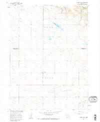
1960 Map of Murray Lake
USGS Topo · Published 1962About this map
Pleasant Hill Cem sits at the intersection of the townships of Hull and Rose, marking a focal point for family history in this corner of the Nebraska panhandle. This 1960 field-checked survey reveals a landscape of high plains ranching and natural drainage, where the arid terrain is defined by dramatic breaks like Bull Canyon and Shoemaker Canyon. The presence of Murray Lake and a small Spring highlight the critical role of surface water in an area largely dominated by open range and section-line roads.
Find a feature on this map
15 named features on this map. Tap any name to fly to it.
Don’t see what you’re looking for? This feature index may not catch every label — zoom into the map to look around manually.
Map Details
Editions of this 1960 Murray Lake Map
2 editions found
Other maps of this area

1898 · Scotts Bluff
USGS Topo · 1:125,000

1899 · Goshen Hole
USGS Topo · 1:125,000

1954 · Scottsbluff
USGS Topo · 1:250,000

1954 · Cheyenne
USGS Topo · 1:250,000

1958 · Cheyenne
USGS Topo · 1:250,000

1958 · Scottsbluff
USGS Topo · 1:250,000

1960 · Tremain
USGS Topo · 1:24,000

1960 · Mc Compsey Pass
USGS Topo · 1:24,000

1960 · Stegall
USGS Topo · 1:24,000
1960 · Robb Draw
USGS Topo · 1:24,000