
1970 Map of Mushaway Peak
USGS Topo · Published 1973About this map
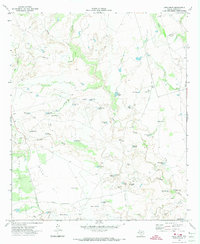
Mushaway Peak stands as the central topographic landmark in this West Texas landscape, overlooking a complex network of ephemeral drainage and ranching infrastructure surveyed in the late 1960s. The terrain is defined by the winding course of the Colorado River in the south and the northern flow of Grape Creek, Little Grape Creek, and Hullem Creek. This area of Borden County is characterized by its reliance on water management for livestock, evidenced by dozens of named catchments such as Cunningham Tank, Shipping Trap Tank, and Red Dam Tank. The map reveals a land utilized for both ranching and mineral extraction, with numerous salt water wells, a Drill Hole, and multiple Gravel Pits scattered across the plains. Large-scale infrastructure is represented by a significant Pipeline cutting through the southern portion of the quadrangle, reflecting the region's mid-century industrial development.
Find a feature on this map
28 named features on this map. Tap any name to fly to it.
Don’t see what you’re looking for? This feature index may not catch every label — zoom into the map to look around manually.
Map Details
Editions of this 1970 Mushaway Peak Map
This is the sole edition of this map. No revisions or reprints were ever made.
Other maps of this area

1954 · Big Spring
USGS Topo · 1:250,000

1958 · Big Spring
USGS Topo · 1:250,000

1969 · Gail
USGS Topo · 1:24,000

1969 · Holloway Canyon
USGS Topo · 1:24,000
1969 · Fivemile Creek
USGS Topo · 1:24,000

1970 · Vealmoor
USGS Topo · 1:24,000
1970 · Gunsight Draw
USGS Topo · 1:24,000
1970 · Gunsight Draw NE
USGS Topo · 1:24,000
1970 · Gunsight Draw SE
USGS Topo · 1:24,000
1970 · Long Draw
USGS Topo · 1:24,000