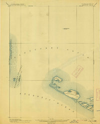
1899 Map of Muskeget
USGS Topo · Published 1913About this map
Muskeget Id. and its surrounding archipelago define this late nineteenth-century maritime landscape where Nantucket Sound meets the Atlantic Ocean. The survey reveals a complex network of shoals and shifting sands, notably the Cross Rip Shoal Light Ship stationed in the northern waters to guide vessels through the treacherous currents of the Muskeget Channel. On Tuckernuck Id., the topography is punctuated by North Pond and East Pond, while the western edge of Nantucket Id. shows the early coastline at Maddaket Harbor and Great Neck. Life-saving stations, marked as L.S.S. on both Muskeget Id. and the main island, underscore the hazards of these waters during an era when coastal navigation was vital to the region's economy and safety. The map provides a clear view of the Dukes and Nantucket county boundary line as it bisects the channel.
Find a feature on this map
22 named features on this map. Tap any name to fly to it.
Don’t see what you’re looking for? This feature index may not catch every label — zoom into the map to look around manually.
Map Details
Editions of this 1899 Muskeget Map
5 editions found

Other maps of this area

1887 · Muskeget
USGS Topo · 1:62,500

1887 · Marthas Vineyard
USGS Topo · 1:62,500

1887 · Yarmouth
USGS Topo · 1:62,500

1889 · Muskeget
USGS Topo · 1:62,500

1889 · Yarmouth
USGS Topo · 1:62,500

1889 · Marthas Vineyard
USGS Topo · 1:62,500

1889 · Nantucket
USGS Topo · 1:62,500

1893 · Nantucket
USGS Topo · 1:62,500

1893 · Muskeget
USGS Topo · 1:62,500

1893 · Yarmouth
USGS Topo · 1:62,500