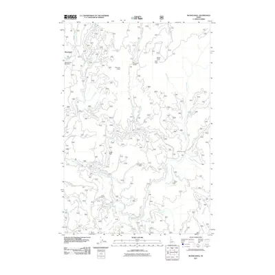
2011 Map of Musselshell
USGS Topo · Published 2011About this map
Musselshell and the adjacent Musselshell Meadows serve as the primary landmarks in this high-country Idaho landscape, where the terrain is defined by a series of prominent divides including Austin Ridge and Chamook Ridge. The drainage network is dense and complex, with Lolo Creek and Musselshell Creek carving through the northern sections, while Eldorado Creek and its many tributaries, such as Six-Bit Creek and Dollar Creek, dominate the eastern slopes. A network of Forest Service roads provides access to isolated points of interest, notably the Austin Ridge Lookout and the Salmon Trout Camp. Small, specifically named sites like Clark Tree suggest localized historical significance within this heavily timbered region. The map captures a moment of active forest management and recreation, where name-places like Chamook Saddle and Eldorado Ridge orient travelers through the deep drainages of Lunch Creek and Trout Creek.
Find a feature on this map
58 named features on this map. Tap any name to fly to it.
Don’t see what you’re looking for? This feature index may not catch every label — zoom into the map to look around manually.
Map Details
Editions of this 2011 Musselshell Map
This is the sole edition of this map. No revisions or reprints were ever made.
Other maps of this area

1924 · Weippe
USGS Topo · 1:125,000

1956 · Hamilton
USGS Topo · 1:250,000

1959 · Hamilton
USGS Topo · 1:250,000

1960 · Hamilton
USGS Topo · 1:250,000

1964 · Hamilton
USGS Topo · 1:250,000

1966 · Pierce
USGS Topo · 1:24,000
1966 · Glenwood
USGS Topo · 1:24,000
1966 · Hemlock Butte
USGS Topo · 1:24,000

1966 · Lowell
USGS Topo · 1:24,000
1966 · Snowy Summit
USGS Topo · 1:24,000