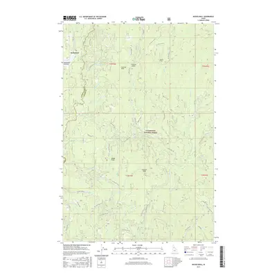
2017 Map of Musselshell
USGS Topo · Published 2017About this map
Musselshell and the surrounding high country of the Clearwater National Forest define this landscape within the Bitterroot Mountains. The terrain is characterized by prominent high points such as Chamook Ridge and Eldorado Ridge, which separate numerous drainages including Musselshell Cr, Eldorado Cr, and Cedar Cr. A network of Forest Service roads, including Musselshell Rd and Lolo Creek Rd, provides access through the steep draws and timbered slopes. Notable landmarks like the Clark Tree and Chamook Saddle serve as navigation points in this remote portion of Idaho County. The map also records localized industrial activity at a Gravel Pit near Brady Cr, and marks the expansive wet opening of Musselshell Meadows, a significant natural feature in an otherwise densely ridged and creek-carved territory.
Find a feature on this map
73 named features on this map. Tap any name to fly to it.
Don’t see what you’re looking for? This feature index may not catch every label — zoom into the map to look around manually.
Map Details
Editions of this 2017 Musselshell Map
This is the sole edition of this map. No revisions or reprints were ever made.
Other maps of this area

1924 · Weippe
USGS Topo · 1:125,000

1956 · Hamilton
USGS Topo · 1:250,000

1959 · Hamilton
USGS Topo · 1:250,000

1960 · Hamilton
USGS Topo · 1:250,000

1964 · Hamilton
USGS Topo · 1:250,000

1966 · Pierce
USGS Topo · 1:24,000
1966 · Glenwood
USGS Topo · 1:24,000
1966 · Hemlock Butte
USGS Topo · 1:24,000

1966 · Lowell
USGS Topo · 1:24,000
1966 · Snowy Summit
USGS Topo · 1:24,000