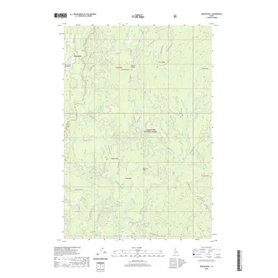
2020 Map of Musselshell
USGS Topo · Published 2020About this map
Musselshell Meadows and the settlement of Musselshell anchor this portion of the Clearwater National Forest, where the landscape is defined by the headwaters of numerous creeks branching from prominent divides. The topography is shaped by Chamook Ridge and Austin Ridge to the north, giving way to Eldorado Ridge further south. A dense network of forest development roads, such as Nat For Dev Rd 5132 and Nat For Dev Rd 101, provides access through the timbered drainages of Musselshell Cr and Lolo Cr. One of the most specific landmarks noted is the Clark Tree, situated between the forks of Dora Cr and Eldorado Cr. The map highlights the intersection of Idaho and Clearwater counties, showing a region committed to forest management and remote land use in the early 21st century.
Find a feature on this map
70 named features on this map. Tap any name to fly to it.
Don’t see what you’re looking for? This feature index may not catch every label — zoom into the map to look around manually.
Map Details
Editions of this 2020 Musselshell Map
This is the sole edition of this map. No revisions or reprints were ever made.
Other maps of this area

1924 · Weippe
USGS Topo · 1:125,000

1956 · Hamilton
USGS Topo · 1:250,000

1959 · Hamilton
USGS Topo · 1:250,000

1960 · Hamilton
USGS Topo · 1:250,000

1964 · Hamilton
USGS Topo · 1:250,000

1966 · Pierce
USGS Topo · 1:24,000
1966 · Glenwood
USGS Topo · 1:24,000
1966 · Hemlock Butte
USGS Topo · 1:24,000

1966 · Lowell
USGS Topo · 1:24,000
1966 · Snowy Summit
USGS Topo · 1:24,000