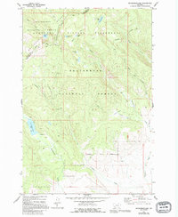
1977 Map of Mussigbrod Lake
USGS Topo · Published 1994About this map
The Continental Divide crests along the Bitterroot Range, forming the high boundary between Ravalli and Beaverhead Counties. This high-elevation wilderness is defined by its network of glacial lakes and the primitive transportation routes used to access them, including the Continental Divide Pack Trail. Notable water bodies like Mussigbrod Lake, Hope Lake, and Mystic Lake feed the headwaters of Plimpton Creek and Mussigbrod Creek. Human activity in this remote region is marked by utilitarian outposts such as a Forest Service Station, a Campground, and a lone Corral in the southern reaches. The map details a landscape transition where the protected Anaconda Pintler Wilderness meets the working lands of the Beaverhead National Forest, preserving the 1970s character of Montana's backcountry before modern developments altered high-country access.
Find a feature on this map
31 named features on this map. Tap any name to fly to it.
Don’t see what you’re looking for? This feature index may not catch every label — zoom into the map to look around manually.
Map Details
Editions of this 1977 Mussigbrod Lake Map
2 editions found
Other maps of this area

1955 · Dillon
USGS Topo · 1:250,000

1957 · Dillon
USGS Topo · 1:250,000

1958 · Dillon
USGS Topo · 1:250,000

1962 · Dillon
USGS Topo · 1:250,000

1962 · Mud Lake
USGS Topo · 1:24,000

1962 · Pintlar Lake
USGS Topo · 1:24,000
1962 · Warren Peak
USGS Topo · 1:24,000

1965 · Dillon
USGS Topo · 1:250,000

1966 · Gibbons School
USGS Topo · 1:24,000

1966 · Big Hole Battlefield
USGS Topo · 1:24,000