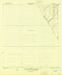
1932 Map of Mustang Bayou
USGS Topo · Published 1946About this map
Arcadia sits at the northern edge of this coastal plain study, surveyed in 1929 by S.B. O'Hara for the Texas Reclamation Department. The map reveals a transition from surveyed settlement to a large Unsurveyed Area that dominates the central portion of the sheet. This distinction likely reflects the drainage and reclamation priorities of the era, focusing mapping efforts on the higher ground and developed corridors while leaving the lower coastal marshlands less detailed. The boundary between Galveston Co and Brazoria Co cuts diagonally across the northeastern corner, following a clear property and survey line that defines the local jurisdictional geography. Because much of the terrain is left blank, the few named features and established roads near the settlements provide essential anchors for understanding the early 20th-century development of the Texas Gulf Coast hinterlands.
Find a feature on this map
3 named features on this map. Tap any name to fly to it.
Don’t see what you’re looking for? This feature index may not catch every label — zoom into the map to look around manually.
Map Details
Editions of this 1932 Mustang Bayou Map
2 editions found
Other maps of this area

1929 · Dickinson
USGS Topo · 1:24,000

1929 · Karankawa Lake
USGS Topo · 1:24,000

1929 · Algoa
USGS Topo · 1:24,000

1929 · Hitchcock
USGS Topo · 1:24,000

1932 · Algoa
USGS Topo · 1:31,680

1932 · Dickinson
USGS Topo · 1:31,680

1932 · Hitchcock
USGS Topo · 1:31,680

1932 · Mustang Bayou
USGS Topo · 1:31,680

1933 · Karankawa Lake
USGS Topo · 1:31,680

1943 · Danbury
USGS Topo · 1:31,680