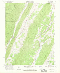
1969 Map of Mustoe
USGS Topo · Published 1970About this map
Lantz Mountain and Monterey Mountain form a steep, parallel corridor through this section of the Alleghenies during the late 1960s. The settlement pattern is strictly dictated by the hydrology of the Jackson River and Back Creek, with small communities like Vanderpool and Mustoe clustered near water gaps. This survey captures a landscape of small upland farms and mountain chapels, including Green Hill Ch and Victory Chapel, as well as the historic Mill Gap crossing. The intersection of local topography and public lands is evident where the George Washington National Forest and Monongahela National Forest meet at the Highland Co and Pocahontas Co border, marking the boundary between Virginia and West Virginia.
Find a feature on this map
40 named features on this map. Tap any name to fly to it.
Don’t see what you’re looking for? This feature index may not catch every label — zoom into the map to look around manually.
Map Details
Editions of this 1969 Mustoe Map
Other maps of this area

1901 · Monterey
USGS Topo · 1:125,000

1922 · Cass
USGS Topo · 1:48,000

1923 · Warm Springs
USGS Topo · 1:48,000

1924 · Cass
USGS Topo · 1:62,500

1926 · Warm Springs
USGS Topo · 1:62,500

1941 · Monterey
USGS Topo · 1:62,500

1944 · Monterey
USGS Topo · 1:62,500

1946 · Warm Springs
USGS Topo · 1:62,500

1946 · Williamsville
USGS Topo · 1:62,500

1949 · Charlottesville
USGS Topo · 1:250,000