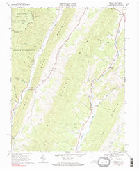
1969 Map of Mustoe
USGS Topo · Published 1984About this map
Lantz Mountain and Jack Mountain dominate this corner of the Virginia-West Virginia border, framing a landscape defined by steep ridges and narrow agricultural gaps. The settlement at Mustoe serves as a central point along the Jackson River, while the western edge of the quadrangle is marked by the Monongahela National Forest and the rugged drainage of Back Creek. The area’s spiritual and social history is anchored by several small congregations, including Green Hill Ch and Victory Chapel, which stand near critical transit points like Mill Gap. This 1960s survey illustrates a rural mountain economy where human activity is tightly constrained by the terrain, with small clusters of homes and family cemeteries scattered along the valley floors near Vanderpool and Valley Center.
Find a feature on this map
41 named features on this map. Tap any name to fly to it.
Don’t see what you’re looking for? This feature index may not catch every label — zoom into the map to look around manually.
Map Details
Editions of this 1969 Mustoe Map
Other maps of this area

1901 · Monterey
USGS Topo · 1:125,000

1922 · Cass
USGS Topo · 1:48,000

1923 · Warm Springs
USGS Topo · 1:48,000

1924 · Cass
USGS Topo · 1:62,500

1926 · Warm Springs
USGS Topo · 1:62,500

1941 · Monterey
USGS Topo · 1:62,500

1944 · Monterey
USGS Topo · 1:62,500

1946 · Warm Springs
USGS Topo · 1:62,500

1946 · Williamsville
USGS Topo · 1:62,500

1949 · Charlottesville
USGS Topo · 1:250,000