
1960 Map of Myers
USGS Topo · Published 1962About this map
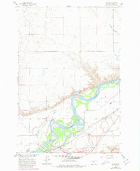
The Yellowstone River winds through the heart of this Treasure County landscape, creating a fertile riparian corridor known as Pease Bottom. During this era of the early 1960s, the region's agricultural character is defined by an intricate network of irrigation, including the Main Canal, Re-Lift Canal, and a prominent Pumping Station. These waterworks supported the small settlement of Myers, situated alongside the Northern Pacific railroad at Myers Siding. North of the river, the terrain rises into the broad Mission Valley, accessed by the Mission Valley Road. This map provides a clear record of local community life through the presence of Rancher Ch and Rancher Sch, serving the families who farmed the river valley. The contrast between the irrigated bottomlands and the dissected coulees like Antelope Coulee illustrates the vital importance of the river to the area's development.
Find a feature on this map
17 named features on this map. Tap any name to fly to it.
Don’t see what you’re looking for? This feature index may not catch every label — zoom into the map to look around manually.
Map Details
Editions of this 1960 Myers Map
2 editions found
Other maps of this area

1954 · Forsyth
USGS Topo · 1:250,000

1957 · Forsyth
USGS Topo · 1:250,000

1958 · Forsyth
USGS Topo · 1:250,000

1960 · Bighorn
USGS Topo · 1:24,000

1960 · Hysham
USGS Topo · 1:24,000

1960 · Steie Ranch
USGS Topo · 1:24,000

1960 · Ahles
USGS Topo · 1:24,000

1960 · Rancher Cemetery
USGS Topo · 1:24,000

1960 · Eldering Ranch
USGS Topo · 1:24,000

1960 · Mc Konkey Creek
USGS Topo · 1:24,000