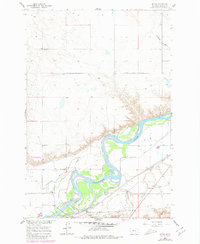
1960 Map of Myers
USGS Topo · Published 1980About this map
The Yellowstone River cuts a wide, meandering path through this portion of Treasure County, defining the agricultural character of Pease Bottom. In the early 1960s, the landscape was heavily influenced by water management and transport, with the Yellowstone Canal, Rancher Ditch, and Hysham Re-Lift Canal supporting the river-valley farms. The Northern Pacific railroad parallels the river, providing a vital link for the small settlement at Myers and its adjacent Myers Siding. This transport corridor is anchored by the presence of a Pumping Station and a local Landing Strip.
Find a feature on this map
22 named features on this map. Tap any name to fly to it.
Don’t see what you’re looking for? This feature index may not catch every label — zoom into the map to look around manually.
Map Details
Editions of this 1960 Myers Map
2 editions found
Other maps of this area

1954 · Forsyth
USGS Topo · 1:250,000

1957 · Forsyth
USGS Topo · 1:250,000

1958 · Forsyth
USGS Topo · 1:250,000

1960 · Bighorn
USGS Topo · 1:24,000

1960 · Hysham
USGS Topo · 1:24,000

1960 · Steie Ranch
USGS Topo · 1:24,000

1960 · Ahles
USGS Topo · 1:24,000

1960 · Myers
USGS Topo · 1:24,000

1960 · Rancher Cemetery
USGS Topo · 1:24,000

1960 · Eldering Ranch
USGS Topo · 1:24,000