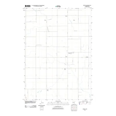
2010 Map of Myrtle
USGS Topo · Published 2010About this map
The small settlement of Myrtle serves as the focal point for this agrarian landscape in Freeborn County, anchored by the Myrtle Post Office. The surrounding countryside is defined by a strict grid of section roads and a remarkably dense distribution of small cemeteries, reflecting the varied immigrant heritage of the local farming community. Notable burial sites include Bohemian Cemetery, Danish Cemetery, and Krikva Cemetery, each serving as a vital landmark for genealogists and local historians tracing regional lineage.
Find a feature on this map
38 named features on this map. Tap any name to fly to it.
Don’t see what you’re looking for? This feature index may not catch every label — zoom into the map to look around manually.
Map Details
Editions of this 2010 Myrtle Map
This is the sole edition of this map. No revisions or reprints were ever made.
Other maps of this area

1954 · Albert Lea
USGS Topo · 1:62,500

1954 · Hayward
USGS Topo · 1:62,500

1954 · Mason City
USGS Topo · 1:250,000

1957 · Mason City
USGS Topo · 1:250,000

1958 · Mason City
USGS Topo · 1:250,000

1972 · Northwood
USGS Topo · 1:24,000

1972 · Fertile NE
USGS Topo · 1:24,000
1972 · Carpenter
USGS Topo · 1:24,000

1982 · Hayward
USGS Topo · 1:24,000
1982 · London
USGS Topo · 1:24,000