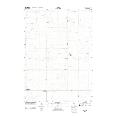
2013 Map of Myrtle
USGS Topo · Published 2013About this map
Myrtle stands as the primary community in this section of Freeborn County, characterized by a highly managed agricultural landscape. The rural grid is defined by extensive drainage systems such as Judicial Ditch Number Twenty and County Ditch Number Fortyine, reflecting the area's transformation for large-scale farming. Notable for genealogists, the map reveals a dense distribution of small rural burial grounds that speak to the heritage of early settlers, including the Bohemian Cem and Krikva Cem. These sites, along with others like Darish Cem and Wanders Rest Cem, are scattered across the terrain between the meandering courses of Deer Cr and Peter Lund Cr. In the southwest corner, the settlement of Gordonsville provides another focal point for local history research near the intersection of Us 65 and the rural road network.
Find a feature on this map
37 named features on this map. Tap any name to fly to it.
Don’t see what you’re looking for? This feature index may not catch every label — zoom into the map to look around manually.
Map Details
Editions of this 2013 Myrtle Map
This is the sole edition of this map. No revisions or reprints were ever made.
Other maps of this area

1954 · Albert Lea
USGS Topo · 1:62,500

1954 · Hayward
USGS Topo · 1:62,500

1954 · Mason City
USGS Topo · 1:250,000

1957 · Mason City
USGS Topo · 1:250,000

1958 · Mason City
USGS Topo · 1:250,000

1972 · Northwood
USGS Topo · 1:24,000

1972 · Fertile NE
USGS Topo · 1:24,000
1972 · Carpenter
USGS Topo · 1:24,000

1982 · Hayward
USGS Topo · 1:24,000
1982 · London
USGS Topo · 1:24,000