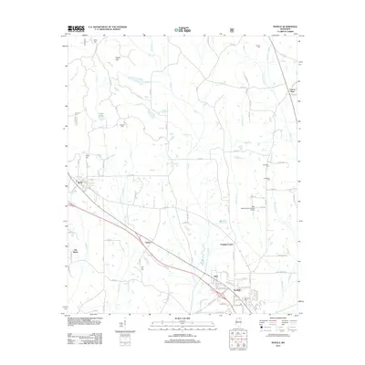
2012 Map of Myrtle
USGS Topo · Published 2012About this map
Myrtle and the adjacent site of Old Myrtle anchor this corner of Union County, reflecting the evolution of local crossroads and rail-side settlements in northern Mississippi. The landscape is characterized by a series of north-south drainage systems, including the uniquely named Damnation Cr and Hell Cr, which flank the central ridges. To the southeast, the growing footprint of Glenfield is evident, situated near the New Albany-Union County Airport.
Find a feature on this map
110 named features on this map. Tap any name to fly to it.
Don’t see what you’re looking for? This feature index may not catch every label — zoom into the map to look around manually.
Map Details
Editions of this 2012 Myrtle Map
This is the sole edition of this map. No revisions or reprints were ever made.
Other maps of this area

1949 · New Albany
USGS Topo · 1:62,500

1951 · New Albany
USGS Topo · 1:62,500

1955 · Ripley
USGS Topo · 1:62,500

1955 · Sherman
USGS Topo · 1:62,500

1955 · Blue Mountain
USGS Topo · 1:62,500

1956 · Tupelo
USGS Topo · 1:250,000

1958 · Tupelo
USGS Topo · 1:250,000

1980 · New Albany West
USGS Topo · 1:24,000
1980 · New Albany East
USGS Topo · 1:24,000
1980 · Etta
USGS Topo · 1:24,000