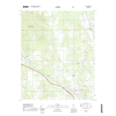
2021 Map of Myrtle
USGS Topo · Published 2021About this map
Holly Springs National Forest covers the northwestern corner of this territory, where the Heipsy Hills rise above the drainage basins of Robbin Cr and Box Cr. This modern topographic survey highlights a landscape defined by small communities and dispersed family landmarks along the Benton, Tippah, and Union county lines. The settlement of Myrtle serves as a local hub, flanked by Old Myrtle and the industrial siding at Smalco. Further east, the New Albany-Union County Airport and the community of Pumpkin Center sit near the northern reaches of New Albany.
Find a feature on this map
95 named features on this map. Tap any name to fly to it.
Don’t see what you’re looking for? This feature index may not catch every label — zoom into the map to look around manually.
Map Details
Editions of this 2021 Myrtle Map
This is the sole edition of this map. No revisions or reprints were ever made.
Other maps of this area

1949 · New Albany
USGS Topo · 1:62,500

1951 · New Albany
USGS Topo · 1:62,500

1955 · Ripley
USGS Topo · 1:62,500

1955 · Sherman
USGS Topo · 1:62,500

1955 · Blue Mountain
USGS Topo · 1:62,500

1956 · Tupelo
USGS Topo · 1:250,000

1958 · Tupelo
USGS Topo · 1:250,000

1980 · New Albany West
USGS Topo · 1:24,000
1980 · New Albany East
USGS Topo · 1:24,000
1980 · Etta
USGS Topo · 1:24,000