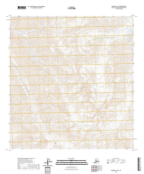
2023 Map of Nabesna A-4 NE
USGS Topo · Published 2023About this map
The Wrangell Mountains dominate this high-altitude Alaskan landscape, where the peaks and ridges rise sharply above the drainages of the Wrangell-Saint Elias National Preserve. This terrain is defined by its deep isolation and dramatic relief, with several prominent creeks carving through the high country. To the northwest, Bond Creek flows through the upper elevations, while Notch Creek and William Creek drain the eastern slopes. The southern portion of the sheet transitions into the protected Wrangell-St. Elias Wilderness, a region characterized by its lack of roads or permanent settlements. The surveyor's notes and section lines from Township 5 North, Range 15 East and surrounding ranges provide the primary structural framework for this otherwise untamed mountain environment.
Find a feature on this map
12 named features on this map. Tap any name to fly to it.
Don’t see what you’re looking for? This feature index may not catch every label — zoom into the map to look around manually.
Map Details
Editions of this 2023 Nabesna A-4 NE Map
This is the sole edition of this map. No revisions or reprints were ever made.
Other maps of this area

1950 · Nabesna
USGS Topo · 1:250,000

1951 · Nabesna
USGS Topo · 1:250,000

1959 · Nabesna A-4
USGS Topo · 1:63,360

1960 · Nabesna B-4
USGS Topo · 1:63,360

1960 · Nabesna A-3
USGS Topo · 1:63,360

1960 · Nabesna
USGS Topo · 1:250,000

1960 · Nabesna B-3
USGS Topo · 1:63,360
2016 · Nabesna A-4 NW
USGS Topo · 1:25,000
2016 · Nabesna B-4 SE
USGS Topo · 1:25,000
2016 · Nabesna A-4 NE
USGS Topo · 1:25,000