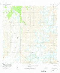
1959 Map of Nabesna A-4
USGS Topo · Published 1975About this map
Orange Hill serves as a lone outpost of human activity in this mid-century survey of the Alaskan interior, located at the edge of the massive Nabesna Glacier. The area reflects the practicalities of remote wilderness access during the late 1950s, centered around the Orange Hill Landing Strip and a nearby Tractor Trail. These rudimentary transportation links were essential for the small-scale operations at the local Quarries, providing the only terrestrial connections through the valley of the Nabesna R.
Find a feature on this map
17 named features on this map. Tap any name to fly to it.
Don’t see what you’re looking for? This feature index may not catch every label — zoom into the map to look around manually.
Map Details
Editions of this 1959 Nabesna A-4 Map
3 editions found
Other maps of this area

1950 · Nabesna
USGS Topo · 1:250,000

1951 · McCarthy
USGS Topo · 1:250,000

1951 · Nabesna
USGS Topo · 1:250,000

1959 · Nabesna A-4
USGS Topo · 1:63,360

1959 · Nabesna A-5
USGS Topo · 1:63,360

1960 · Nabesna B-4
USGS Topo · 1:63,360

1960 · Nabesna B-5
USGS Topo · 1:63,360

1960 · Nabesna A-3
USGS Topo · 1:63,360

1960 · McCarthy D-6
USGS Topo · 1:63,360

1960 · Nabesna
USGS Topo · 1:250,000