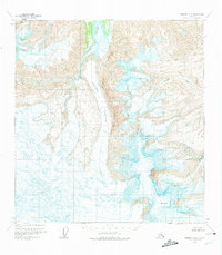
1959 Map of Nabesna A-6
USGS Topo · Published 1975About this map
Mt Jarvis dominates the southeastern terrain of this 1959 photogrammetric survey, overlooking a landscape defined by massive ice fields and glacial meltwater. The central valley is carved by the Copper Glacier, which feeds directly into the headwaters of the Copper River. This map captures the region before extensive environmental changes, showing the intricate network of crevasses and lateral moraines that characterized the ice flows during the mid-twentieth century. To the east, the Jacksina Glacier pushes through steep mountain passes, while the West Glacier and Tumble Creek mark the western and northern boundaries of this high-altitude wilderness. The U.S. Geological Survey utilized 1957 aerial photography to document these remote drainage patterns, providing a precise record of the ice margins as they existed decades ago.
Find a feature on this map
7 named features on this map. Tap any name to fly to it.
Don’t see what you’re looking for? This feature index may not catch every label — zoom into the map to look around manually.
Map Details
Editions of this 1959 Nabesna A-6 Map
2 editions found
Other maps of this area

1950 · Nabesna
USGS Topo · 1:250,000

1951 · McCarthy
USGS Topo · 1:250,000

1951 · Gulkana
USGS Topo · 1:250,000

1951 · Nabesna
USGS Topo · 1:250,000

1952 · Valdez
USGS Topo · 1:250,000

1959 · Gulkana B-1
USGS Topo · 1:63,360
1959 · Gulkana A-1
USGS Topo · 1:63,360

1959 · Gulkana
USGS Topo · 1:250,000

1959 · Nabesna A-6
USGS Topo · 1:63,360

1959 · Valdez D-1
USGS Topo · 1:63,360