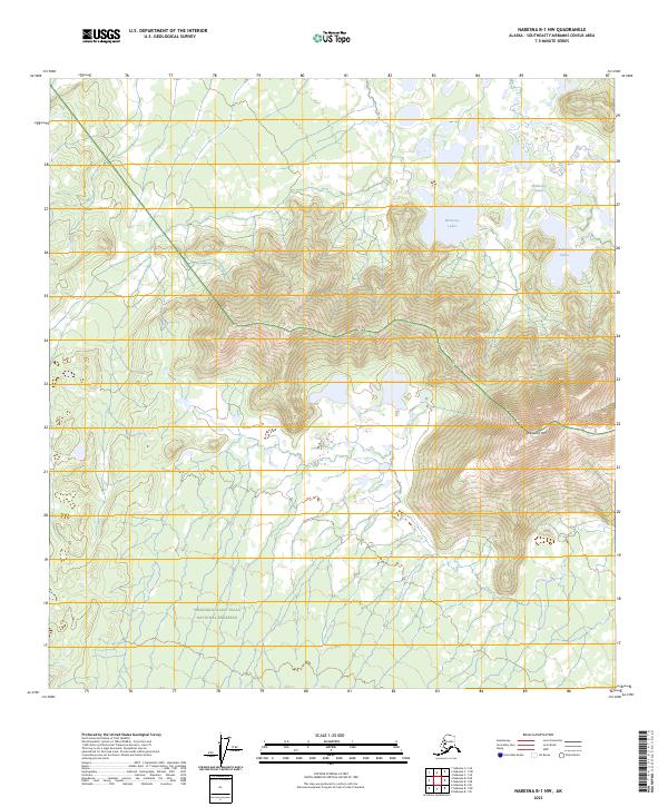
2023 Map of Nabesna B-1 NW
USGS Topo · Published 2023About this map
Tetlin National Wildlife Refuge and the northern edge of the Wrangell-Saint Elias National Preserve meet in this 2023 survey of the Southeast Fairbanks Census Area. The terrain is defined by the high prominence of Wellesley Mtn, which rises above a landscape of numerous small water bodies. The northeastern portion of the sheet is dominated by the Wellesley Lakes, while the Stevens Lakes are situated further south at the base of the mountain slopes. This modern record of the Alaska interior shows a largely roadless territory, where the topography transitions from the wetland-dense refuge in the north to the higher elevations and preserved lands of the Wrangell-Saint Elias region to the south. The map provides a detailed view of the natural hydrology and elevation contours that characterize this subarctic wilderness.
Find a feature on this map
9 named features on this map. Tap any name to fly to it.
Don’t see what you’re looking for? This feature index may not catch every label — zoom into the map to look around manually.
Map Details
Editions of this 2023 Nabesna B-1 NW Map
This is the sole edition of this map. No revisions or reprints were ever made.
Other maps of this area

1950 · Nabesna
USGS Topo · 1:250,000

1951 · Nabesna
USGS Topo · 1:250,000

1955 · Nabesna C-1
USGS Topo · 1:63,360

1955 · Nabesna C-2
USGS Topo · 1:63,360

1960 · Nabesna B-2
USGS Topo · 1:63,360

1960 · Nabesna
USGS Topo · 1:250,000

1960 · Nabesna B-1
USGS Topo · 1:63,360
2016 · Nabesna B-2 NE
USGS Topo · 1:25,000
2016 · Nabesna B-1 NE
USGS Topo · 1:25,000
2016 · Nabesna C-2 SE
USGS Topo · 1:25,000