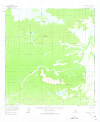
1960 Map of Nabesna B-1
USGS Topo · Published 1975About this map
The Alaska Yukon boundary defines the eastern edge of this 1960 landscape, where the wilderness of the United States Canada border meets the high country of the Carden Hills. The terrain is dominated by a complex network of wetlands and high ridges, anchored by Wellesley Mountain in the north and drained by the winding course of Snag Creek. Human presence is minimal, represented primarily by a Winter Trail in the southwest, indicating the seasonal nature of movement through this region before modern infrastructure. The hydrology of the area is particularly intricate, featuring the expansive Wellesley Lakes and Stevens Lakes in the northern basin, while the southern slopes descend toward Carden Lake and the headwaters of Cottonwood Creek.
Find a feature on this map
11 named features on this map. Tap any name to fly to it.
Don’t see what you’re looking for? This feature index may not catch every label — zoom into the map to look around manually.
Map Details
Editions of this 1960 Nabesna B-1 Map
2 editions found
Other maps of this area

1950 · Nabesna
USGS Topo · 1:250,000

1951 · Nabesna
USGS Topo · 1:250,000

1955 · Nabesna C-1
USGS Topo · 1:63,360

1955 · Nabesna C-2
USGS Topo · 1:63,360

1959 · Nabesna A-1
USGS Topo · 1:63,360

1960 · Nabesna A-2
USGS Topo · 1:63,360

1960 · Nabesna B-2
USGS Topo · 1:63,360

1960 · Nabesna
USGS Topo · 1:250,000

1960 · Nabesna B-1
USGS Topo · 1:63,360
2016 · Nabesna A-2 NE
USGS Topo · 1:25,000