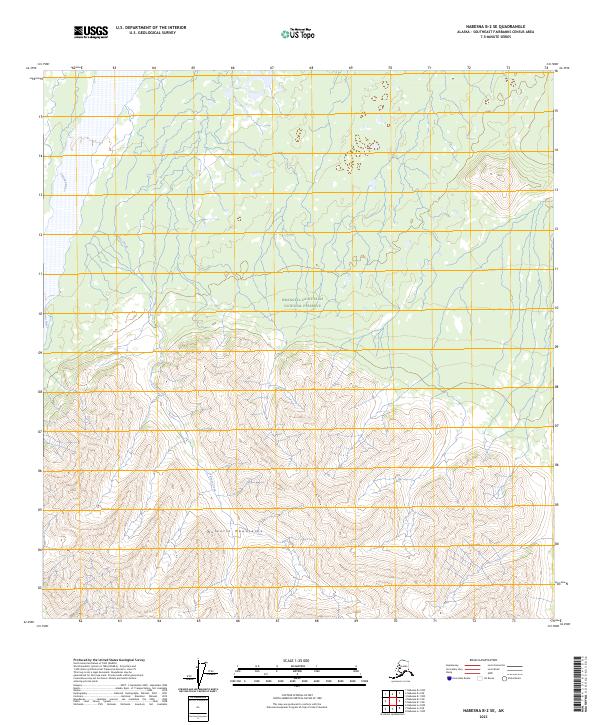
2023 Map of Nabesna B-2 SE
USGS Topo · Published 2023About this map
The Wrangell-Saint Elias National Preserve encompasses a significant portion of this high-altitude landscape, where the Nutzotin Mountains dominate the southern half of the quadrangle. The terrain transitions from the braided valley of the Chisana River in the northwest to the complex ridges and drainages of the interior. Seasonal watercourses like Bruin Creek carve through the steep topography, illustrating the drainage patterns that define this sub-arctic environment. This 2023 survey provides a clear view of the public land survey system divisions across townships t7n r20e, t7n r21e, and t6n r20e, revealing a wilderness devoid of modern roads or permanent settlements. The map is a valuable resource for understanding the remote geography of the Southeast Fairbanks Census Area within one of the nation's largest protected wilderness regions.
Find a feature on this map
9 named features on this map. Tap any name to fly to it.
Don’t see what you’re looking for? This feature index may not catch every label — zoom into the map to look around manually.
Map Details
Editions of this 2023 Nabesna B-2 SE Map
This is the sole edition of this map. No revisions or reprints were ever made.
Other maps of this area

1950 · Nabesna
USGS Topo · 1:250,000

1951 · Nabesna
USGS Topo · 1:250,000

1959 · Nabesna A-1
USGS Topo · 1:63,360

1960 · Nabesna A-2
USGS Topo · 1:63,360

1960 · Nabesna B-2
USGS Topo · 1:63,360

1960 · Nabesna
USGS Topo · 1:250,000

1960 · Nabesna B-1
USGS Topo · 1:63,360
2016 · Nabesna A-2 NE
USGS Topo · 1:25,000
2016 · Nabesna B-2 NE
USGS Topo · 1:25,000
2016 · Nabesna B-2 SE
USGS Topo · 1:25,000