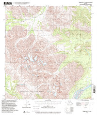
1960 Map of Nabesna C-4
USGS Topo · Published 2000About this map
The Mentasta Mountains dominate this 1960 Alaska landscape, providing the high-altitude drainage for a complex system of glacial and mountain waterways. The northern slopes fall within the Tetlin National Wildlife Refuge, while the southern reaches are preserved as part of the Wrangell-Saint Elias National Preserve. The hydrography of the region is centered on the broad course of the Nabesna River and the winding Cheslina River, with smaller features like Mineral Springs and Soda Lake indicating the distinct geology of the interior. Human presence is minimal, recorded only through a remote Cabin and a network of transit routes including a Pack Trail and a Tractor Trail. These paths follow the natural contours of the Tellin River and Totschunda Creek, showing the limited but vital infrastructure used for wilderness travel before the turn of the century.
Find a feature on this map
20 named features on this map. Tap any name to fly to it.
Don’t see what you’re looking for? This feature index may not catch every label — zoom into the map to look around manually.
Map Details
Editions of this 1960 Nabesna C-4 Map
4 editions found

Other maps of this area

1948 · Nabesna D-5
USGS Topo · 1:63,360

1950 · Nabesna
USGS Topo · 1:250,000

1950 · Nabesna D-5
USGS Topo · 1:63,360

1951 · Nabesna
USGS Topo · 1:250,000

1952 · Nabesna D-5
USGS Topo · 1:63,360

1954 · Nabesna D-3
USGS Topo · 1:63,360

1954 · Nabesna C-3
USGS Topo · 1:63,360

1954 · Nabesna D-4
USGS Topo · 1:63,360

1955 · Nabesna D-3
USGS Topo · 1:63,360

1955 · Nabesna C-3
USGS Topo · 1:63,360