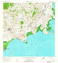
1957 Map of Naguabo
USGS Topo · Published 1960About this map
The Roosevelt Roads Naval Reservation dominates the eastern coast of this mid-century survey, showing the military installation alongside established sugar industry infrastructure. The Fajardo Eastern Sugar Associates railroad lines and the Development Company tracks trace the economic patterns of the era, connecting inland areas like Mariana and Daguao to the coast. Coastal life is centered around Playa de Naguabo and the Puerto Naguabo, where the Río Santiago meets the Bahía Algodones.
Find a feature on this map
82 named features on this map. Tap any name to fly to it.
Don’t see what you’re looking for? This feature index may not catch every label — zoom into the map to look around manually.
Map Details
Editions of this 1957 Naguabo Map
This is the sole edition of this map. No revisions or reprints were ever made.
Other maps of this area

1945 · El Yunque
USGS Topo · 1:30,000

1946 · El Yunque
USGS Topo · 1:30,000

1946 · Humacao
USGS Topo · 1:30,000

1946 · Punta Puerca
USGS Topo · 1:30,000

1946 · Naguabo
USGS Topo · 1:30,000

1946 · Fajardo
USGS Topo · 1:30,000
1947 · Humacao SE
USGS Topo · 1:10,000

1947 · El Yunque SE
USGS Topo · 1:10,000
1947 · Humacao NE
USGS Topo · 1:10,000

1947 · Naguabo NE
USGS Topo · 1:10,000