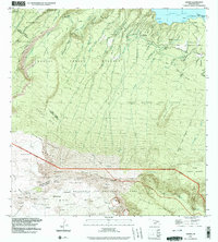
1992 Map of Nahiku
USGS Topo · Published 2003About this map
Nāhiku and the Nāhiku Homesteads sit along the winding Hana Highway, anchored to a coast defined by Honolulu Nui Bay and ‘Ōpūhano Bay. The landscape rises sharply from the Pacific toward the rim of Haleakalā Crater, where the Haleakalā National Park boundary meets the Hana Forest Reserve. This terrain is deeply etched by a series of parallel drainage systems, including the Wailua Iki Stream and Kopiliula Stream, which feed landmarks like Kopiliula Falls. Local history is preserved in small coastal cemeteries and the gaging stations that monitored the island's vital water flow. Hikers and researchers can trace the Haleakalā Trail as it crosses the Kaupo Gap near Paliku Cabin, while the Hanawī Natural Area Reserve protects the higher elevations of the Kūhiwa Valley.
Find a feature on this map
62 named features on this map. Tap any name to fly to it.
Don’t see what you’re looking for? This feature index may not catch every label — zoom into the map to look around manually.
Map Details
Editions of this 1992 Nahiku Map
This is the sole edition of this map. No revisions or reprints were ever made.
Other maps of this area

1954 · Maui
USGS Topo · 1:250,000

1957 · Kilohana
USGS Topo · 1:24,000

1957 · Kipahulu
USGS Topo · 1:24,000

1957 · Hana
USGS Topo · 1:24,000

1957 · Haiku
USGS Topo · 1:24,000

1957 · Lualailua Hills
USGS Topo · 1:24,000

1957 · Nahiku
USGS Topo · 1:24,000

1957 · Kaupo
USGS Topo · 1:24,000

1957 · Keanae
USGS Topo · 1:24,000

1966 · Maui
USGS Topo · 1:250,000