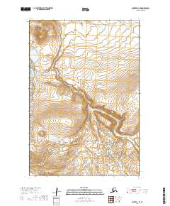
2019 Map of Naknek A-1 SE
USGS Topo · Published 2019About this map
The Becharof National Wildlife Refuge dominates this section of the Alaska Peninsula, preserving a landscape defined by glacial topography and riparian corridors. In the northern reaches of the quadrangle, Gertrude Cr meanders eastward through the tundra, representing the sparse but vital water networks that sustain local ecosystems. The 2019 survey provides a clear view of the complex elevation changes in the Lake and Peninsula Borough, from the relatively flat drainage basins to the significant relief of the southern hills. While human infrastructure is absent on this map, the precise surveying of township and range boundaries, including t24s r42w and t25s r41w, provides an essential framework for understanding land management and conservation in this remote territory.
Find a feature on this map
6 named features on this map. Tap any name to fly to it.
Don’t see what you’re looking for? This feature index may not catch every label — zoom into the map to look around manually.
Map Details
Editions of this 2019 Naknek A-1 SE Map
This is the sole edition of this map. No revisions or reprints were ever made.
Other maps of this area

1943 · Ugashik
USGS Topo · 1:250,000

1948 · Mt Katmai
USGS Topo · 1:250,000

1948 · Ugashik
USGS Topo · 1:250,000

1949 · Ugashik
USGS Topo · 1:250,000

1951 · Mt Katmai
USGS Topo · 1:250,000

1951 · Karluk
USGS Topo · 1:250,000

1951 · Mount Katmai A-6
USGS Topo · 1:63,360

1951 · Ugashik D-1
USGS Topo · 1:63,360

1951 · Karluk D-6
USGS Topo · 1:63,360

1951 · Naknek A-1
USGS Topo · 1:63,360