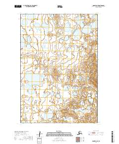
2019 Map of Naknek A-5 SE
USGS Topo · Published 2019About this map
Red Bluff serves as a prominent landmark in this segment of the Alaska Peninsula, situated within the Lake and Peninsula Borough. The landscape is defined by an intricate network of wetlands and small water bodies that dominate the western half of the territory, reflecting the glacial and fluvial history of the Naknek region. Surveyed for the t24s r50w and t24s r49w townships, the area shows no established roads or settlements, highlighting its character as a remote wilderness at the time of this 2019 data compilation. Geologic contours reveal the subtle elevation changes between the marshy lowlands and the higher ground of the eastern ridges, providing a clear view of the hydrological patterns that shape this subarctic environment.
Find a feature on this map
5 named features on this map. Tap any name to fly to it.
Don’t see what you’re looking for? This feature index may not catch every label — zoom into the map to look around manually.
Map Details
Editions of this 2019 Naknek A-5 SE Map
This is the sole edition of this map. No revisions or reprints were ever made.
Other maps of this area

1943 · Ugashik
USGS Topo · 1:250,000

1948 · Ugashik
USGS Topo · 1:250,000

1949 · Ugashik
USGS Topo · 1:250,000

1951 · Ugashik D-5 and D-6
USGS Topo · 1:63,360

1951 · Ugashik D-4
USGS Topo · 1:63,360

1951 · Naknek A-5
USGS Topo · 1:63,360

1951 · Naknek A-4
USGS Topo · 1:63,360

1952 · Naknek
USGS Topo · 1:250,000

1963 · Ugashik
USGS Topo · 1:250,000

1964 · Naknek
USGS Topo · 1:250,000