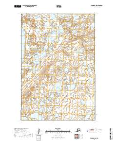
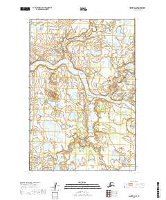
2019 Map of Naknek D-3 SW
USGS Topo · Published 2019About this map
Kvichak Bay dominates the western shoreline of this coastal landscape, where the tidal influence meets a dense network of subarctic wetlands and tundra ponds. The map captures a largely untouched wilderness area defined by the meandering course of Graveyard Creek as it flows toward the bay. This specific corner of the Bristol Bay region is characterized by its complex hydrology, featuring numerous unnamed lakes and marshes that dominate the interior sections of the township grids. Near the center of the sheet, the label Naknek appears adjacent to a significant inland water body, likely representing a local hydrological feature rather than the established settlement of the same name located further afield. The map serves as a detailed record of the shifting shoreline and seasonal drainage patterns essential to the region's ecology and traditional land use.
Find a feature on this map
7 named features on this map. Tap any name to fly to it.
Don’t see what you’re looking for? This feature index may not catch every label — zoom into the map to look around manually.
Map Details
Editions of this 2019 Naknek D-3 SW Map
This is the sole edition of this map. No revisions or reprints were ever made.
Other maps of this area

1952 · Naknek
USGS Topo · 1:250,000

1952 · Naknek C-3
USGS Topo · 1:63,360

1952 · Naknek D-3
USGS Topo · 1:63,360

1952 · Naknek D-4
USGS Topo · 1:63,360

1952 · Naknek C-4
USGS Topo · 1:63,360

1964 · Naknek
USGS Topo · 1:250,000
2019 · Naknek D-3 NW
USGS Topo · 1:25,000
2019 · Naknek C-3 NW
USGS Topo · 1:25,000
2019 · Naknek D-4 SE
USGS Topo · 1:25,000
2019 · Naknek C-3 NE
USGS Topo · 1:25,000