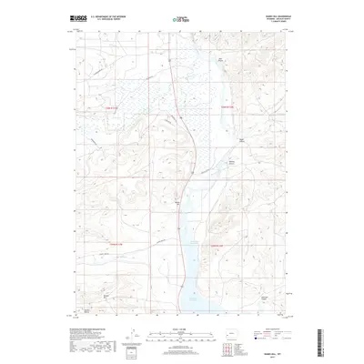
2017 Map of Names Hill
USGS Topo · Published 2017About this map
Names Hill rises above the Green River valley, serving as a landmark in this Wyoming landscape where high desert terrain meets the waters of the Fontenelle Reservoir. The geography is defined by a series of significant drainages and canyons, including Spur Canyon, Steed Canyon, and Anderson Canyon, which cut through the high ground east of the river. The presence of the Sublette Cutoff indicates the historical importance of this corridor as a transit route through Lincoln County. To the west, the land transitions into lower-lying basins fed by La Barge Cr and Muddy Cr, with prominent elevations like Holden Hill and Holden Hollow marking the southwestern quadrant. This survey shows the modern road network, including La Barge Creek Rd and Muddy Creek Rd, overlaid on a landscape still deeply marked by its traditional creek systems and natural canyon formations.
Find a feature on this map
22 named features on this map. Tap any name to fly to it.
Don’t see what you’re looking for? This feature index may not catch every label — zoom into the map to look around manually.
Map Details
Editions of this 2017 Names Hill Map
This is the sole edition of this map. No revisions or reprints were ever made.
Other maps of this area

1945 · Fort Hill
USGS Topo · 1:62,500

1947 · Fort Hill
USGS Topo · 1:62,500

1955 · Preston
USGS Topo · 1:250,000

1958 · Preston
USGS Topo · 1:250,000

1962 · Preston
USGS Topo · 1:250,000

1968 · Anderson Canyon
USGS Topo · 1:24,000

1968 · Fontenelle Reservoir SE
USGS Topo · 1:24,000

1968 · Names Hill
USGS Topo · 1:24,000

1968 · Fontenelle Reservoir SW
USGS Topo · 1:24,000

1969 · La Barge
USGS Topo · 1:24,000