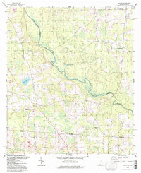
1994 Map of Nankin
USGS Topo · Published 1998About this map
The Withlacoochee River carves a winding path through this corner of South Georgia and North Florida, defining the border between Brooks and Lowndes counties. This region is characterized by its numerous small, rural congregations, including Silver Run Ch, Beulah Ch, and Ochlawilla Ch, which serve the dispersed agricultural community. The small settlement of Nankin acts as a central point for the local network of roads and paths, situated near a Gravel Pit and the Columbia Ch.
Find a feature on this map
22 named features on this map. Tap any name to fly to it.
Don’t see what you’re looking for? This feature index may not catch every label — zoom into the map to look around manually.
Map Details
Editions of this 1994 Nankin Map
This is the sole edition of this map. No revisions or reprints were ever made.
Other maps of this area

1954 · Valdosta
USGS Topo · 1:250,000

1956 · Clyattville
USGS Topo · 1:24,000

1956 · Nankin
USGS Topo · 1:24,000

1956 · Baden
USGS Topo · 1:24,000

1958 · Valdosta
USGS Topo · 1:250,000

1959 · Valdosta
USGS Topo · 1:250,000

1960 · Cherry Lake
USGS Topo · 1:24,000

1960 · Pinetta
USGS Topo · 1:24,000

1961 · Quitman
USGS Topo · 1:62,500

1961 · Valdosta
USGS Topo · 1:24,000