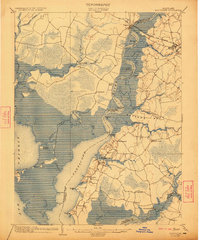
1903 Map of Nanticoke
USGS Topo · Published 1922About this map
Nanticoke River navigation and tidal marshlands define this coastal landscape at the start of the twentieth century, where the water served as the primary highway for commerce. The map clearly delineates a Steamboat Route winding past Sandy Hill Landing and Athaloo Ldg., connecting remote river settlements like Vienna and Whitehaven to wider Chesapeake markets. Along the eastern shore of the river, a dense network of small villages such as Tyaskin, Bivalve, and Jesterville suggests a bustling seafood-based economy, while the Baltimore Chesapeake and Atlantic R. R. provides a critical rail link further inland through Mardela Springs. To the west, the expansive marshes of Fishing Bay are punctuated by isolated landings like Bestpitch and Elliott, illustrating the geographic challenges of the Dorchester County wetlands. This survey documents the final era before modern bridges and highways significantly altered the historical reliance on river landings and local ferry crossings.
Find a feature on this map
63 named features on this map. Tap any name to fly to it.
Don’t see what you’re looking for? This feature index may not catch every label — zoom into the map to look around manually.
Map Details
Editions of this 1903 Nanticoke Map
4 editions found
Other maps of this area

1898 · Choptank
USGS Topo · 1:125,000

1898 · St. Marys
USGS Topo · 1:125,000

1901 · Salisbury
USGS Topo · 1:62,500

1903 · Nanticoke
USGS Topo · 1:62,500

1903 · Bloodsworth Island
USGS Topo · 1:62,500

1903 · Deal Island
USGS Topo · 1:62,500

1904 · Oxford
USGS Topo · 1:62,500

1905 · Crapo
USGS Topo · 1:62,500

1905 · Hurlock
USGS Topo · 1:62,500

1906 · St. Marys
USGS Topo · 1:125,000