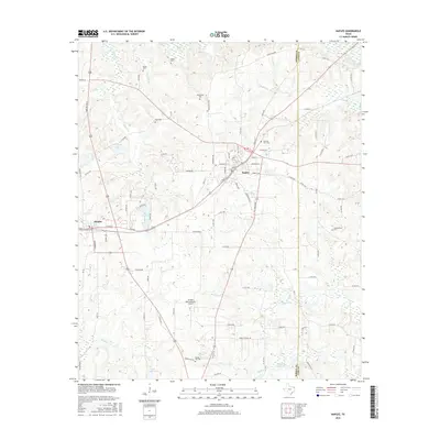
2016 Map of Naples
USGS Topo · Published 2016About this map
Naples and Omaha anchor this portion of East Texas, where the landscape is defined by the headwaters of numerous creeks and several small reservoirs. This 2016 survey highlights a region shaped by its proximity to the Morris and Cass county line, featuring the Greater Morris County Airport as a modern central landmark. The rural character of the area is emphasized by a high density of family and community burial grounds, including the Heard, Milner, Wheatville, and Hart cemeteries, which offer significant clues for local genealogical research.
Find a feature on this map
100 named features on this map. Tap any name to fly to it.
Don’t see what you’re looking for? This feature index may not catch every label — zoom into the map to look around manually.
Map Details
Editions of this 2016 Naples Map
This is the sole edition of this map. No revisions or reprints were ever made.
Other maps of this area

1914 · Daingerfield
USGS Topo · 1:62,500

1930 · Bassett
USGS Topo · 1:62,500

1953 · Texarkana
USGS Topo · 1:250,000

1956 · Texarkana
USGS Topo · 1:250,000

1964 · Daingerfield
USGS Topo · 1:24,000

1964 · Cason
USGS Topo · 1:24,000

1965 · Marietta
USGS Topo · 1:24,000

1965 · Dalby Springs
USGS Topo · 1:24,000
1965 · Sardis
USGS Topo · 1:24,000
1965 · Bassett
USGS Topo · 1:24,000