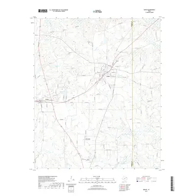
2019 Map of Naples
USGS Topo · Published 2019About this map
Naples and Omaha anchor this Morris County landscape, where the local road network connects small rural communities with longstanding family and civic landmarks. Numerous burial grounds are scattered throughout the quadrangle, including the Heard Cem, Milner Cem, and Morning Star Cem, providing a detailed record for genealogical research in this part of East Texas. The terrain is defined by several watercourses such as Village Cr and Caney Cr, which flow through a region characterized by private lakes like RE Moore Lake and Justiss Farms Lake. Transportation infrastructure is centered around the Greater Morris County Airport and the local thoroughfare of W Main St, while the boundary between Morris Co and Cass Co runs along the eastern edge of the survey area.
Find a feature on this map
100 named features on this map. Tap any name to fly to it.
Don’t see what you’re looking for? This feature index may not catch every label — zoom into the map to look around manually.
Map Details
Editions of this 2019 Naples Map
This is the sole edition of this map. No revisions or reprints were ever made.
Other maps of this area

1914 · Daingerfield
USGS Topo · 1:62,500

1930 · Bassett
USGS Topo · 1:62,500

1953 · Texarkana
USGS Topo · 1:250,000

1956 · Texarkana
USGS Topo · 1:250,000

1964 · Daingerfield
USGS Topo · 1:24,000

1964 · Cason
USGS Topo · 1:24,000

1965 · Marietta
USGS Topo · 1:24,000

1965 · Dalby Springs
USGS Topo · 1:24,000
1965 · Sardis
USGS Topo · 1:24,000
1965 · Bassett
USGS Topo · 1:24,000