
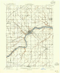
1908 Map of Napoleon
USGS Topo · Published 1942About this map
The Maumee River serves as the central artery for this Northwest Ohio landscape, defining the development of Napoleon and several riverside hamlets. During this early twentieth-century era, the Miami and Erie Canal still parallels the river's northern bank, representing an older era of transport that was rapidly being overtaken by a dense network of steel rails. Five distinct rail lines, including the Wabash RR and the Detroit Toledo and Ironton RR, intersect the terrain, creating bustling junctions at small settlements like Malinta and Holgate.
Find a feature on this map
56 named features on this map. Tap any name to fly to it.
Don’t see what you’re looking for? This feature index may not catch every label — zoom into the map to look around manually.
Map Details
Editions of this 1908 Napoleon Map
2 editions found
Other maps of this area

1907 · Defiance
USGS Topo · 1:62,500

1908 · Ottawa
USGS Topo · 1:62,500

1909 · Mc Clure
USGS Topo · 1:62,500

1909 · Defiance
USGS Topo · 1:62,500

1909 · Continental
USGS Topo · 1:62,500

1911 · Wauseon
USGS Topo · 1:62,500

1911 · Swanton
USGS Topo · 1:62,500

1913 · Wauseon
USGS Topo · 1:62,500

1913 · Alvordton
USGS Topo · 1:62,500

1914 · Swanton
USGS Topo · 1:62,500