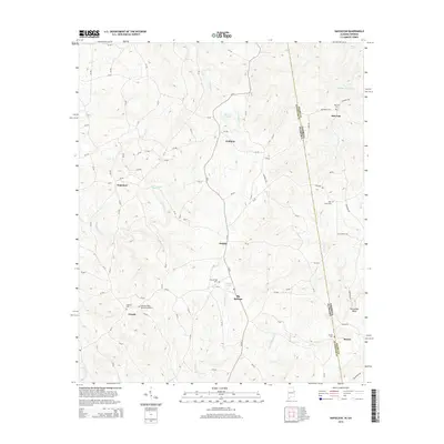
2014 Map of Napoleon
USGS Topo · Published 2014About this map
The borderlands of Randolph Co and Heard County are defined by the winding course of Wehadkee Cr and its numerous tributaries. This survey captures the rural character of the region, where small settlements like Napoleon and Omaha serve as local hubs for the surrounding farmsteads and woodlands. The landscape is a network of ridges and creek valleys, notably the Wedowee Cr drainage and the distinct Horseshoe Bend loop. For genealogists, the map is particularly useful for its documentation of local burial grounds, including Big Springs Cem, High Point Cem, and the Highway Ridge Memorial Gardens. Modern infrastructure is represented by the north-south corridor of Highway 340, which connects the communities of Waldrep and Big Springs, while smaller roads like CR-87 provide access to more secluded water bodies such as Moores Pond and Higgins Lake.
Find a feature on this map
102 named features on this map. Tap any name to fly to it.
Don’t see what you’re looking for? This feature index may not catch every label — zoom into the map to look around manually.
Map Details
Editions of this 2014 Napoleon Map
This is the sole edition of this map. No revisions or reprints were ever made.
Other maps of this area

1899 · Wedowee
USGS Topo · 1:125,000

1902 · Wedowee
USGS Topo · 1:125,000

1953 · Atlanta
USGS Topo · 1:250,000

1957 · Atlanta
USGS Topo · 1:250,000

1958 · Atlanta
USGS Topo · 1:250,000

1964 · Glenn
USGS Topo · 1:24,000

1964 · Roopville
USGS Topo · 1:24,000
1964 · Frolona
USGS Topo · 1:24,000
1969 · Roanoke East
USGS Topo · 1:24,000
1969 · Newell
USGS Topo · 1:24,000