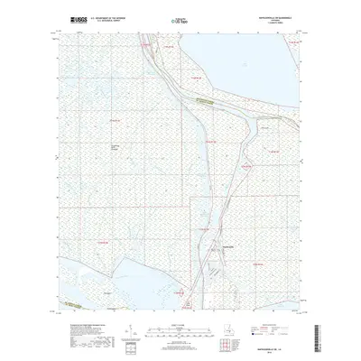
2018 Map of Napoleonville SW
USGS Topo · Published 2018About this map
Stephenville sits at a critical hydrologic junction where the Belle River meets Bayou Long, serving as a gateway to the labyrinthine wetlands of south Louisiana. The landscape is dominated by the Atchafalaya Basin Floodway, a vast network of bayous and canals that manage the pulse of the region's waters. Major arteries like the Gulf Intracoastal Waterway and the Intracoastal Waterway slice through the swamp, facilitating industrial and commercial transit between larger water bodies such as Lake Verret to the northeast and Lake Palourde to the south.
Find a feature on this map
41 named features on this map. Tap any name to fly to it.
Don’t see what you’re looking for? This feature index may not catch every label — zoom into the map to look around manually.
Map Details
Editions of this 2018 Napoleonville SW Map
This is the sole edition of this map. No revisions or reprints were ever made.
Other maps of this area

1935 · Morgan City
USGS Topo · 1:62,500

1941 · Belle Isle
USGS Topo · 1:62,500

1945 · New Orleans
USGS Topo · 1:250,000

1948 · Foster
USGS Topo · 1:62,500

1953 · Napoleonville
USGS Topo · 1:62,500

1954 · Morgan City
USGS Topo · 1:62,500

1954 · Belle Isle
USGS Topo · 1:62,500

1959 · Foster
USGS Topo · 1:62,500

1963 · New Orleans
USGS Topo · 1:250,000
1965 · Grassy Lake
USGS Topo · 1:24,000