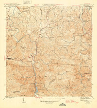
1946 Map of Naranjito
USGS Topo · Published 1946About this map
Rio Plata snakes through the center of this 1940s survey, anchoring a landscape defined by sharp elevation changes and agricultural colonies. The terrain is marked by numerous churches and small settlements, such as Colonia Sabana and Colonia Santa Rosa, reflecting the rural community structure of the era. A significant industrial presence is seen at the Represa de Comerio and the nearby Planta Hidroelectrica, which highlight the importance of hydroelectric power in the region's development.
Find a feature on this map
89 named features on this map. Tap any name to fly to it.
Don’t see what you’re looking for? This feature index may not catch every label — zoom into the map to look around manually.
Map Details
Editions of this 1946 Naranjito Map
3 editions found
Other maps of this area

1940 · Vega Alta
USGS Topo · 1:30,000

1941 · Bayamon
USGS Topo · 1:30,000

1941 · San Juan
USGS Topo · 1:30,000

1946 · Aguas Buenas
USGS Topo · 1:30,000

1946 · Corozal
USGS Topo · 1:30,000

1946 · Barranquitas
USGS Topo · 1:30,000

1946 · Vega Alta
USGS Topo · 1:30,000

1946 · Comerio
USGS Topo · 1:30,000

1946 · Naranjito
USGS Topo · 1:30,000

1946 · Caguas
USGS Topo · 1:30,000
Featured Places
- Naranjito
- Camino del Monte, Guaynabo
- Sector Los Cobos, Bayamón
- Sector Los Fonseca, Bayamón
- Sector Goveo García, Bayamón