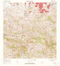
1969 Map of Naranjito
USGS Topo · Published 1972About this map
The Rio de la Plata carves a deep, winding path through this central Puerto Rican landscape, serving as a primary geographic anchor for the Naranjito and Bayamón regions. In the northern reaches, suburban expansion is evident in the residential grids of Royal Town, Santa Juanita, and Lomas Verdes, where numerous named streets like Calle Iralda and Calle Fenix define the emerging urban footprint.
Find a feature on this map
209 named features on this map. Tap any name to fly to it.
Don’t see what you’re looking for? This feature index may not catch every label — zoom into the map to look around manually.
Map Details
Editions of this 1969 Naranjito Map
3 editions found
Other maps of this area

1940 · Vega Alta
USGS Topo · 1:30,000

1941 · Bayamon
USGS Topo · 1:30,000

1941 · San Juan
USGS Topo · 1:30,000

1946 · Aguas Buenas
USGS Topo · 1:30,000

1946 · Corozal
USGS Topo · 1:30,000

1946 · Barranquitas
USGS Topo · 1:30,000

1946 · Vega Alta
USGS Topo · 1:30,000

1946 · Comerio
USGS Topo · 1:30,000

1946 · Naranjito
USGS Topo · 1:30,000

1946 · Caguas
USGS Topo · 1:30,000
Featured Places
- Naranjito
- Sector Correa, Naranjito
- Villas del Olimpo, Bayamón
- Sector La Capilla, Bayamón
- Sector González, Bayamón