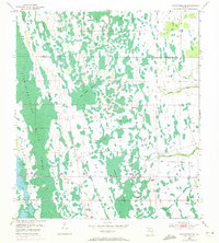
1953 Map of Narcoossee SE
USGS Topo · Published 1972About this map
The Econlockhatchee River Swamp dominates this landscape along the boundary of Orange and Osceola counties, revealing a complex network of wetlands and seasonal watercourses as they appeared in the early 1950s. The terrain is defined by dense stands of cypress and hardwoods, punctuated by uniquely named features such as Hell Bays and Bee Tree Swamp. A notable piece of industrial history is the Old Railroad Grade, which cuts through the swampy lowlands, providing evidence of former logging or transit routes that once traversed this interior region.
Find a feature on this map
21 named features on this map. Tap any name to fly to it.
Don’t see what you’re looking for? This feature index may not catch every label — zoom into the map to look around manually.
Map Details
Editions of this 1953 Narcoossee SE Map
4 editions found
Other maps of this area

1953 · Narcoossee NE
USGS Topo · 1:24,000

1953 · Narcoossee SE
USGS Topo · 1:24,000

1953 · Narcoossee
USGS Topo · 1:24,000

1953 · Deer Park NW
USGS Topo · 1:24,000

1953 · Lake Poinsett SW
USGS Topo · 1:24,000

1953 · Ashton
USGS Topo · 1:24,000

1953 · Holopaw
USGS Topo · 1:24,000

1953 · Lake Poinsett NW
USGS Topo · 1:24,000

1953 · Narcoossee NW
USGS Topo · 1:24,000

1955 · Orlando
USGS Topo · 1:250,000