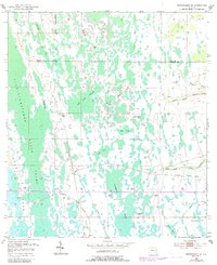
1953 Map of Narcoossee SE
USGS Topo · Published 1988About this map
The Econlockhatchee River defines the western edge of this central Florida landscape, weaving through a dense network of wetlands and namesake pools. This 1950s era survey, later updated with late-century revisions, documents the intricate hydrology of the Bee Tree Swamp and the uniquely named Hell Bays. The presence of an Old Railroad Grade cutting east-to-west across the terrain suggests a legacy of early transport through the marshes, leading toward Storey Crossing on the edge of the Fourmile Swamp. Further south, the Sawgrass Slough and family-named landmarks like Storey Bend and Rawlson Head provide significant reference points for local history. The map also traces the headwaters of the Taylor Creek system, including the North Fork Taylor Creek and South Fork Taylor Creek, where the land begins to transition into better-drained hammocks and ponds like Otter Pond.
Find a feature on this map
20 named features on this map. Tap any name to fly to it.
Don’t see what you’re looking for? This feature index may not catch every label — zoom into the map to look around manually.
Map Details
Editions of this 1953 Narcoossee SE Map
4 editions found
Other maps of this area

1953 · Narcoossee NE
USGS Topo · 1:24,000

1953 · Narcoossee SE
USGS Topo · 1:24,000

1953 · Narcoossee
USGS Topo · 1:24,000

1953 · Deer Park NW
USGS Topo · 1:24,000

1953 · Lake Poinsett SW
USGS Topo · 1:24,000

1953 · Ashton
USGS Topo · 1:24,000

1953 · Holopaw
USGS Topo · 1:24,000

1953 · Lake Poinsett NW
USGS Topo · 1:24,000

1953 · Narcoossee NW
USGS Topo · 1:24,000

1955 · Orlando
USGS Topo · 1:250,000