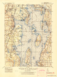
1919 Map of Narragansett Bay
USGS Topo · Published 1921About this map
Conanicut Island and Prudence Island anchor this detailed tactical study of the bay's central waters, produced shortly after the Great War. The landscape reveals a complex network of coastal infrastructure, from the U.S. Naval Training Sta. at Newport to the industrial presence of the Portsmouth Coal Mines on the northern tip of Rhode Island. Transport patterns of the era are clearly defined, featuring electrified lines like the Warren and Bristol RR alongside traditional steam routes such as the Narragansett Pier RR. The presence of the State Prison and State Farm near Oaklawn suggests the institutional character of the northern interior, while coastal landmarks like Rocky Point and Shawomet Beach highlight the region's early 20th-century character as a maritime hub. Navigational aids, including Plum Beach Light and Poplar Point Light, are meticulously noted to support maritime and tactical operations across the bay.
Find a feature on this map
140 named features on this map. Tap any name to fly to it.
Don’t see what you’re looking for? This feature index may not catch every label — zoom into the map to look around manually.
Map Details
Editions of this 1919 Narragansett Bay Map
2 editions found

Other maps of this area

1885 · Sakonnet
USGS Topo · 1:62,500

1885 · Taunton
USGS Topo · 1:62,500

1887 · Providence
USGS Topo · 1:62,500

1888 · Fall River
USGS Topo · 1:62,500

1888 · Taunton
USGS Topo · 1:62,500

1888 · Sakonnet
USGS Topo · 1:62,500

1889 · Charlestown
USGS Topo · 1:62,500

1889 · Providence
USGS Topo · 1:62,500

1889 · Newport
USGS Topo · 1:62,500

1889 · Burrillville
USGS Topo · 1:62,500