
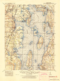
1919 Map of Narragansett Bay
USGS Topo · Published 1921About this map
Warwick Light and Prudence I. Light stand as critical maritime markers on this coastal survey, which details the intricate shoreline of Rhode Island's largest estuary. The landscape is defined by its transit-oriented growth, where the New York New Haven and Hartford R.R. and the Sea View Electric R.R. link established settlements like East Greenwich and Wickford. The presence of the Portsmouth Coal Mines and the U.S. Naval Coaling Sta. on the northern end of Aquidneck Island reflects the era's heavy industrial and military reliance on fossil fuels.
Find a feature on this map
172 named features on this map. Tap any name to fly to it.
Don’t see what you’re looking for? This feature index may not catch every label — zoom into the map to look around manually.
Map Details
Editions of this 1919 Narragansett Bay Map
2 editions found
Other maps of this area

1885 · Sakonnet
USGS Topo · 1:62,500

1885 · Taunton
USGS Topo · 1:62,500

1887 · Providence
USGS Topo · 1:62,500

1888 · Fall River
USGS Topo · 1:62,500

1888 · Taunton
USGS Topo · 1:62,500

1888 · Sakonnet
USGS Topo · 1:62,500

1889 · Charlestown
USGS Topo · 1:62,500

1889 · Providence
USGS Topo · 1:62,500

1889 · Newport
USGS Topo · 1:62,500

1889 · Burrillville
USGS Topo · 1:62,500