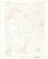
1965 Map of Narraguinnep Mountain
USGS Topo · Published 1968About this map
Narraguinnep Mountain dominates this portion of the San Juan National Forest in Southwest Colorado, anchoring a landscape defined by an extensive network of small water catchments. The 1965 field survey reveals a terrain heavily modified for water management, featuring dozens of named sites like Buster Reservoir, Young Reservoir, and Flatiron Reservoir. This concentration of reservoirs suggests a period of intensive land use for grazing or resource management within the forest boundaries. High points such as Ormiston Point and Elston Mountain overlook the Dolores and Montezuma county line, which bisects the southern reaches of the map. Natural water sources like Narraguinnep Spring and Trimble Spring provided vital stops along the early Jeep Trail and Driveway routes that once cut through these high-elevation woods.
Find a feature on this map
59 named features on this map. Tap any name to fly to it.
Don’t see what you’re looking for? This feature index may not catch every label — zoom into the map to look around manually.
Map Details
Editions of this 1965 Narraguinnep Mountain Map
4 editions found
Other maps of this area

1956 · Cortez
USGS Topo · 1:250,000

1958 · Cortez
USGS Topo · 1:250,000

1959 · Cortez
USGS Topo · 1:250,000

1962 · Cortez
USGS Topo · 1:250,000

1964 · Glade Mountain
USGS Topo · 1:24,000

1964 · The Glade
USGS Topo · 1:24,000
1964 · South Mountain
USGS Topo · 1:24,000

1965 · Willow Spring
USGS Topo · 1:24,000

1965 · Yellow Jacket
USGS Topo · 1:24,000
1965 · Boggy Draw
USGS Topo · 1:24,000