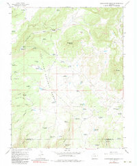
1965 Map of Narraguinnep Mountain
USGS Topo · Published 1983About this map
San Juan National Forest defines the rugged geography of this mid-1960s survey on the border of Dolores and Montezuma counties. The landscape is a network of canyons and high points, anchored by Narraguinnep Mountain and the steep walls of Narraguinnep Canyon. A distinct pattern of water management is visible through dozens of small impoundments like Buster Reservoir, Hosea Reservoir, and Nielson Reservoir, which likely served the local ranching and seasonal grazing economy.
Find a feature on this map
63 named features on this map. Tap any name to fly to it.
Don’t see what you’re looking for? This feature index may not catch every label — zoom into the map to look around manually.
Map Details
Editions of this 1965 Narraguinnep Mountain Map
4 editions found
Other maps of this area

1956 · Cortez
USGS Topo · 1:250,000

1958 · Cortez
USGS Topo · 1:250,000

1959 · Cortez
USGS Topo · 1:250,000

1962 · Cortez
USGS Topo · 1:250,000

1964 · Glade Mountain
USGS Topo · 1:24,000

1964 · The Glade
USGS Topo · 1:24,000
1964 · South Mountain
USGS Topo · 1:24,000

1965 · Willow Spring
USGS Topo · 1:24,000

1965 · Yellow Jacket
USGS Topo · 1:24,000
1965 · Boggy Draw
USGS Topo · 1:24,000