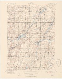
1951 Map of Nashville
USGS Topo · Published 1951About this map
The Thornapple River winds through this mid-century landscape, anchoring a network of small agricultural settlements and rural schoolhouses across Barry and Eaton Counties. The village of Nashville serves as a central hub along the New York Central railroad, which connects it to neighboring Vermontville and the hamlet of Morgan. This era captures a high density of one-room schoolhouses still identified by name, such as Bismark Sch, Ragla Sch, and Hosmer Sch, reflecting the community-centered educational structure before widespread consolidation.
Find a feature on this map
92 named features on this map. Tap any name to fly to it.
Don’t see what you’re looking for? This feature index may not catch every label — zoom into the map to look around manually.
Map Details
Editions of this 1951 Nashville Map
2 editions found

Other maps of this area

1916 · Ionia
USGS Topo · 1:62,500

1918 · Battle Creek
USGS Topo · 1:62,500

1918 · Ionia
USGS Topo · 1:62,500

1918 · Galesburg
USGS Topo · 1:62,500

1918 · Lowell
USGS Topo · 1:62,500

1921 · Marshall
USGS Topo · 1:62,500

1923 · Marshall
USGS Topo · 1:62,500

1943 · Battle Creek
USGS Topo · 1:62,500

1943 · Marshall
USGS Topo · 1:62,500

1943 · Ionia
USGS Topo · 1:62,500