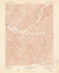
1949 Map of Nashville
USGS Topo · Published 1949About this map
Brown County State Park dominates the southern landscape of this mid-century survey, showcasing a complex network of ridges and hollows that define the regional geography. The county seat of Nashville sits at the junction of State Routes 46 and 135, serving as the primary hub for a scattered rural population. The drainage patterns of North Fork Salt Creek and its many tributaries, such as Clay Lick Creek and Green Valley Creek, dictated the placement of early infrastructure. Genealogists will find a wealth of local landmarks, including the Greasy Creek Ch and isolated burial grounds like David Cem and Reeves Cem. Educational history is preserved through the locations of the Clark Sch and Mt Liberty Sch, while unique place names like Gnaw Bone and Pikes Peak highlight the distinct local identity of the area.
Find a feature on this map
60 named features on this map. Tap any name to fly to it.
Don’t see what you’re looking for? This feature index may not catch every label — zoom into the map to look around manually.
Map Details
Editions of this 1949 Nashville Map
2 editions found

Other maps of this area

1942 · Franklin
USGS Topo · 1:125,000

1946 · Belmont
USGS Topo · 1:24,000

1947 · Nashville
USGS Topo · 1:24,000

1947 · Elkinsville
USGS Topo · 1:24,000

1947 · Franklin
USGS Topo · 1:62,500

1948 · New Bellsville
USGS Topo · 1:24,000

1948 · Waymansville
USGS Topo · 1:24,000

1948 · Nineveh
USGS Topo · 1:24,000

1948 · Fruitdale
USGS Topo · 1:24,000

1948 · Morgantown
USGS Topo · 1:24,000