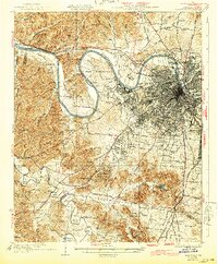
1932 Map of Nashville
USGS Topo · Published 1943About this map
The Cumberland River carves a dramatic series of oxbows across this landscape, defining the rural and institutional character of West Nashville. At Cockrill Bend, the massive State Reservation and Penitentiary occupy the isolated peninsula, while the nearby County Farm sits just across the water from Bordeaux. This period of development shows the city's growth pressing south and west, where the Nashville Chattanooga and St Louis railway and the Louisville and Nashville tracks intersect at Radnor.
Find a feature on this map
105 named features on this map. Tap any name to fly to it.
Don’t see what you’re looking for? This feature index may not catch every label — zoom into the map to look around manually.
Map Details
Editions of this 1932 Nashville Map
2 editions found
Other maps of this area

1901 · Colombia
USGS Topo · 1:125,000

1903 · Nashville
USGS Topo · 1:125,000

1909 · Franklin
USGS Topo · 1:62,500

1930 · White Bluff
USGS Topo · 1:62,500

1931 · Ridgetop
USGS Topo · 1:62,500

1932 · Hermitage
USGS Topo · 1:62,500

1932 · Nashville
USGS Topo · 1:62,500

1933 · White Bluff
USGS Topo · 1:62,500

1935 · Ridgetop
USGS Topo · 1:62,500

1942 · Gallatin
USGS Topo · 1:100,000