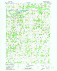
1981 Map of Nashville
USGS Topo · Published 1981About this map
The Thornapple River winds through this central Michigan landscape, defining the character of the village of Nashville and the neighboring community of Vermontville. As seen in the late 1970s, the region maintains its rural layout, centered on a network of highways like Kinsel Highway and Valley Highway. Significant local landmarks provide anchors for genealogical research, including the Maple Grove Ch and several burial grounds such as Wilcox Cem and Quaker Cem. The map illustrates the transition from village centers to organized agricultural land across townships like Castleton and Kalamo. Industrial activity is evident in the numerous Gravel Pits and Quarry sites scattered near Quaker Brook and Scipio Creek. Educational hubs such as Maple Valley High Sch and Fuller Sch are clearly marked, serving the spread-out rural population.
Find a feature on this map
55 named features on this map. Tap any name to fly to it.
Don’t see what you’re looking for? This feature index may not catch every label — zoom into the map to look around manually.
Map Details
Editions of this 1981 Nashville Map
This is the sole edition of this map. No revisions or reprints were ever made.
Other maps of this area

1918 · Battle Creek
USGS Topo · 1:62,500

1921 · Marshall
USGS Topo · 1:62,500

1923 · Marshall
USGS Topo · 1:62,500

1943 · Battle Creek
USGS Topo · 1:62,500

1943 · Marshall
USGS Topo · 1:62,500

1947 · Bellevue
USGS Topo · 1:24,000

1947 · Bedford
USGS Topo · 1:24,000

1949 · Charlotte
USGS Topo · 1:62,500

1950 · Battle Creek
USGS Topo · 1:62,500

1950 · Nashville
USGS Topo · 1:62,500